 |
|
|
|
|
|
|
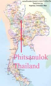
Phitsanulok Thailand
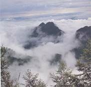
Mountain Region
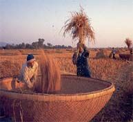
Plain Region |
Geography, Climate, Population
Geography Phitsanulok province covers some 10,815.854 square kilometers. The riverside provincial is 377 Kilometers north of Bangkok. Phitsanulok is situated on the Geographical and administrative line uniting the central and northern regions. It borders with Uttaradit in the North, Pichit in the South, Loei and Phetchabun in the East, Kamphaeng Phet and Sukothai in the West. Phitsanulok consists of the mountain region which is one third covers the east and north part of Phitsanulok and the rest is the plain region. The mountain region is medium - high, the highest point is Phu soi Dow ( 2,102 meters above sea ) and Phu Hin Rong Kla (1,617 meters above sea ), so this part has the cold weather all the year and it also covers with forest. Also this part has many water falls and caves such as Kaeng Sopha waterfall. The plain region has many rivers such as Nan river and kwae Noi river these two river make Phitsanulok named " Song Kwae " because "Song" in Thai means two and " Kwae " in Thai means rivers, the plain region also has the fertile crop fields.This part has many people and it is also the commercial part. |
|
|
|